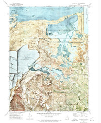
1972 Map of Plain City SW
USGS Topo · Published 1974About this map
The eastern shores of the Great Salt Lake are defined here by a complex landscape of wetlands and industrial infrastructure during the early 1970s. The Harold S Crane Waterfowl Management Area and Willard Bay dominate the northern portion, showcasing the region's importance as a migratory corridor. The presence of numerous sportsman associations, including the Ogden Gun Club and George East Gun Club, underscores a local culture tied to these marshlands.
Find a feature on this map
38 named features on this map. Tap any name to fly to it.
Don’t see what you’re looking for? This feature index may not catch every label — zoom into the map to look around manually.
Map Details
Editions of this 1972 Plain City SW Map
This is the sole edition of this map. No revisions or reprints were ever made.
Other maps of this area

1954 · Whistler Canal
USGS Topo · 1:24,000

1954 · Brigham City
USGS Topo · 1:250,000

1955 · Plain City
USGS Topo · 1:24,000

1955 · Roy
USGS Topo · 1:24,000

1955 · Willard Spur
USGS Topo · 1:24,000

1955 · Mouth of Bear River
USGS Topo · 1:24,000

1955 · Plain City SW
USGS Topo · 1:24,000

1955 · Willard
USGS Topo · 1:24,000

1955 · Ogden Bay
USGS Topo · 1:24,000

1955 · Fremont Island
USGS Topo · 1:24,000