
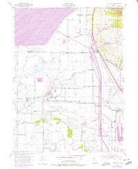
1955 Map of Plain City
USGS Topo · Published 1956About this map
The Weber River and its intricate network of irrigation canals define the landscape of this mid-century Utah agricultural region. Numerous waterworks including the West Weber Canal, Warren Canal, and Brigham Canal supported established farming communities like Plain City and Farr West. Near the northern edge, Utah Hot Springs serves as a distinct landmark along the Union Pacific tracks, accompanied by a roadside swimming pool and nearby gravel pits.
Find a feature on this map
51 named features on this map. Tap any name to fly to it.
Don’t see what you’re looking for? This feature index may not catch every label — zoom into the map to look around manually.
Map Details
Editions of this 1955 Plain City Map
2 editions found
Other maps of this area

1954 · Whistler Canal
USGS Topo · 1:24,000

1954 · Ogden
USGS Topo · 1:250,000

1954 · Brigham City
USGS Topo · 1:250,000

1955 · Ogden
USGS Topo · 1:24,000

1955 · Roy
USGS Topo · 1:24,000

1955 · Mantua
USGS Topo · 1:24,000

1955 · Plain City SW
USGS Topo · 1:24,000

1955 · Willard
USGS Topo · 1:24,000

1955 · North Ogden
USGS Topo · 1:24,000

1955 · Ogden Bay
USGS Topo · 1:24,000