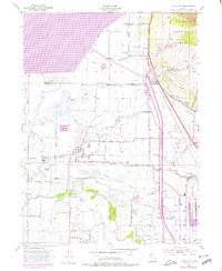
1955 Map of Plain City
USGS Topo · Published 1978About this map
The Weber River and the vast expanse of the Willard Reservoir dominate this landscape during a period of transition for Weber County. This survey captures the intricate irrigation and drainage network essential to the region, featuring the Willard Canal, Brigham Canal, and Ogden Canal alongside numerous smaller waterways like Fourmile Creek and Salt Creek. The rail-centered economy of the mid-20th century is evident through the Union Pacific lines and an Old Railroad Grade near Warren.
Find a feature on this map
62 named features on this map. Tap any name to fly to it.
Don’t see what you’re looking for? This feature index may not catch every label — zoom into the map to look around manually.
Map Details
Editions of this 1955 Plain City Map
2 editions found
Other maps of this area

1954 · Whistler Canal
USGS Topo · 1:24,000

1954 · Ogden
USGS Topo · 1:250,000

1954 · Brigham City
USGS Topo · 1:250,000

1955 · Ogden
USGS Topo · 1:24,000

1955 · Plain City
USGS Topo · 1:24,000

1955 · Roy
USGS Topo · 1:24,000

1955 · Mantua
USGS Topo · 1:24,000

1955 · Plain City SW
USGS Topo · 1:24,000

1955 · Willard
USGS Topo · 1:24,000

1955 · North Ogden
USGS Topo · 1:24,000