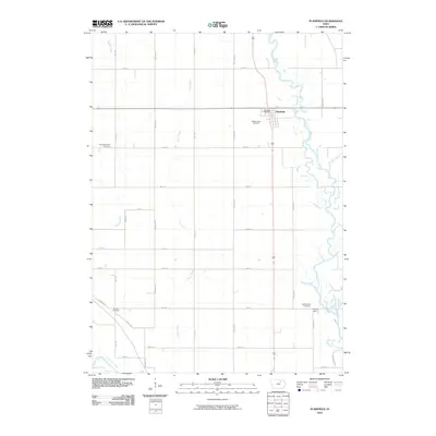
2010 Map of Plainfield
USGS Topo · Published 2010About this map
The settlement of Plainfield occupies the northeast quadrant of this study, positioned near the winding path of the Cedar River. As a localized center for the surrounding agricultural community in Bremer County, the town is home to the Plainfield Post Office and the nearby Willow Lawn Cemetery. The landscape is defined by its drainage systems, with the Shell Rock River cutting across the southwest corner while Beaver Creek, Curry Creek, and Horton Creek thread through the township's grid of section roads. This 2010 survey illustrates the persistence of rural landmarks, including several dispersed burial grounds such as Antioch Cemetery, Spring Lake Cemetery, and Pleasant Valley Cemetery. The relationship between the meandering riverbanks and the rigid agricultural parcels highlights the adaptation of local infrastructure to the varied riparian terrain of the Spring Lake area.
Find a feature on this map
34 named features on this map. Tap any name to fly to it.
Don’t see what you’re looking for? This feature index may not catch every label — zoom into the map to look around manually.
Map Details
Editions of this 2010 Plainfield Map
This is the sole edition of this map. No revisions or reprints were ever made.
Other maps of this area

1954 · Waterloo
USGS Topo · 1:250,000

1955 · Waterloo
USGS Topo · 1:250,000

1963 · Waverly
USGS Topo · 1:24,000

1971 · Shell Rock
USGS Topo · 1:24,000

1971 · Bremer
USGS Topo · 1:24,000

1971 · Tripoli NW
USGS Topo · 1:24,000

1971 · Coster
USGS Topo · 1:24,000

1971 · Plainfield
USGS Topo · 1:24,000

1971 · Nashua NW
USGS Topo · 1:24,000

1971 · Clarksville
USGS Topo · 1:24,000