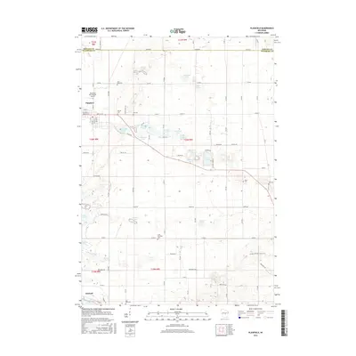
2015 Map of Plainfield
USGS Topo · Published 2015About this map
Plainfield and the surrounding central Wisconsin farmland are characterized by a dense concentration of kettle lakes and a meticulously gridded township-and-range road system. This landscape reflects the glacial legacy of the region, where numerous named water bodies like Plainfield Lake, Sherman Lake, and Lake Huron are scattered across the terrain. The presence of multiple burial grounds, including Hillside Cem, Saint Pauls Cem, and Ray Cem, indicates long-standing rural community centers established throughout the townships of t20n r8e and t20n r9e. The map also traces a segment of the Ice Age National Scenic Trail as it winds through the southeastern corner near Hancock, providing a clear record of modern recreational land use alongside the traditional agricultural and aviation infrastructure of the Plainfield International Airport.
Find a feature on this map
62 named features on this map. Tap any name to fly to it.
Don’t see what you’re looking for? This feature index may not catch every label — zoom into the map to look around manually.
Map Details
Editions of this 2015 Plainfield Map
This is the sole edition of this map. No revisions or reprints were ever made.
Other maps of this area

1955 · Green Bay
USGS Topo · 1:250,000

1957 · Amherst
USGS Topo · 1:48,000

1957 · Whiting
USGS Topo · 1:48,000

1958 · Coloma
USGS Topo · 1:48,000

1959 · Wautoma
USGS Topo · 1:48,000

1968 · Coloma
USGS Topo · 1:24,000

1968 · Richford
USGS Topo · 1:24,000

1968 · Plainfield
USGS Topo · 1:24,000
1968 · Wautoma
USGS Topo · 1:24,000

1968 · Hancock
USGS Topo · 1:24,000