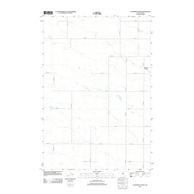
2012 Map of Plainview Colony
USGS Topo · Published 2012About this map
Plainview Colony stands as a focal point of communal living and agricultural organization in this portion of Edmunds County. The landscape is defined by the rigid North American Public Land Survey System, with a network of numbered section-line roads such as 125th St and 357th Ave carving the prairie into precise squares. This structured human imprint contrasts with the numerous small, scattered wetlands and basins that dot the terrain, including Rosette Lake. The placement of the colony itself, situated near the intersection of 124th St and 359th Ave, reflects the ongoing importance of Hutterite agricultural settlements in South Dakota’s modern rural fabric. The map illustrates a highly managed landscape where modern infrastructure and traditional communal farming practices meet.
Find a feature on this map
17 named features on this map. Tap any name to fly to it.
Don’t see what you’re looking for? This feature index may not catch every label — zoom into the map to look around manually.
Map Details
Editions of this 2012 Plainview Colony Map
This is the sole edition of this map. No revisions or reprints were ever made.
Other maps of this area

1899 · Ellendale
USGS Topo · 1:125,000

1899 · Northville
USGS Topo · 1:125,000

1954 · Aberdeen
USGS Topo · 1:250,000

1956 · Aberdeen
USGS Topo · 1:250,000

1970 · Mina NW
USGS Topo · 1:24,000

1970 · Leola
USGS Topo · 1:24,000

1970 · Leola SW
USGS Topo · 1:24,000

1978 · Beebe
USGS Topo · 1:24,000
1978 · Ipswich
USGS Topo · 1:24,000
1978 · Plainview Colony
USGS Topo · 1:24,000