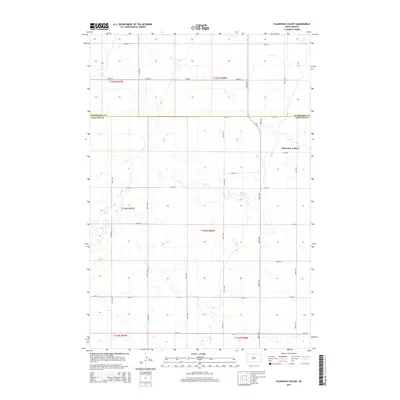
2015 Map of Plainview Colony
USGS Topo · Published 2015About this map
Plainview Colony occupies a central role in this agrarian landscape along the boundary of McPherson and Edmunds counties. The terrain is defined by a meticulous grid of section-line roads, including 122nd St and 354th Ave, which facilitate movement through the expansive agricultural tracts of the northern Great Plains. A notable natural feature is Rosette Lake, situated in the central-eastern portion of the quadrangle. This area reflects a highly organized communal settlement pattern, where the infrastructure is primarily geared toward large-scale farming and livestock management. The road network, from Cr-13 to the numerous numbered streets and avenues, reveals a landscape where the natural topography has been systematically divided into the Public Land Survey System townships of t124n r68w and surrounding ranges.
Find a feature on this map
25 named features on this map. Tap any name to fly to it.
Don’t see what you’re looking for? This feature index may not catch every label — zoom into the map to look around manually.
Map Details
Editions of this 2015 Plainview Colony Map
This is the sole edition of this map. No revisions or reprints were ever made.
Other maps of this area

1899 · Ellendale
USGS Topo · 1:125,000

1899 · Northville
USGS Topo · 1:125,000

1954 · Aberdeen
USGS Topo · 1:250,000

1956 · Aberdeen
USGS Topo · 1:250,000

1970 · Mina NW
USGS Topo · 1:24,000

1970 · Leola
USGS Topo · 1:24,000

1970 · Leola SW
USGS Topo · 1:24,000

1978 · Beebe
USGS Topo · 1:24,000
1978 · Ipswich
USGS Topo · 1:24,000
1978 · Plainview Colony
USGS Topo · 1:24,000