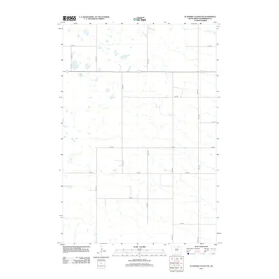
2012 Map of Plainview Colony NE
USGS Topo · Published 2012About this map
Foot Cr meanders across this northern section of McPherson County, defining the drainage patterns of an otherwise heavily gridded agricultural landscape. The 2012 survey illustrates a classic South Dakota township-and-range layout, where local transport is dictated by a strict network of section-line roads such as 114th St and 357th Ave. This area is characterized by numerous small, scattered wetlands and depressions that interrupt the cultivated fields, a signature of the glaciated prairie pothole region. While the landscape is dominated by open acreage, the precise mapping of intersections like 118th St and 355th Ave provides a modern snapshot of rural land division and the enduring structure of the Great Plains farming economy.
Find a feature on this map
14 named features on this map. Tap any name to fly to it.
Don’t see what you’re looking for? This feature index may not catch every label — zoom into the map to look around manually.
Map Details
Editions of this 2012 Plainview Colony NE Map
This is the sole edition of this map. No revisions or reprints were ever made.
Other maps of this area

1899 · Ellendale
USGS Topo · 1:125,000

1954 · Aberdeen
USGS Topo · 1:250,000

1956 · Aberdeen
USGS Topo · 1:250,000

1968 · Long Lake
USGS Topo · 1:24,000

1968 · Long Lake SE
USGS Topo · 1:24,000

1968 · Forbes SW
USGS Topo · 1:24,000

1970 · Leola
USGS Topo · 1:24,000

1970 · Leola SW
USGS Topo · 1:24,000
1978 · Plainview Colony
USGS Topo · 1:24,000
1978 · Plainview Colony NE
USGS Topo · 1:24,000