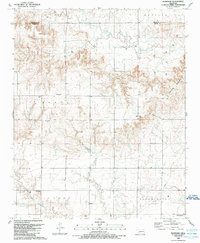
1989 Map of Plainview
USGS Topo · Published 1989About this map
The boundary between Beckham and Greer Counties runs through this Western Oklahoma landscape, where the high plains meet the intricate canyon systems of the Red River watershed. In the late 1980s, the small community of Plainview served as a local hub, situated just north of the Plainview Cem and south of the headwaters of Haystack Creek. The map reveals a transition from the agricultural plateaus of Rainey and Willow townships to the more broken terrain of the southwest, marked by the presence of Jester Cave. This area's natural resource economy is evident through numerous Gas Wells and pipelines that lace across the sections. To the south, the settlements of Jester and Bloomington sit near the winding course of Deer Creek, anchored by local institutions like the Deer Creek Ch and Jester Cem.
Find a feature on this map
21 named features on this map. Tap any name to fly to it.
Don’t see what you’re looking for? This feature index may not catch every label — zoom into the map to look around manually.
Map Details
Editions of this 1989 Plainview Map
This is the sole edition of this map. No revisions or reprints were ever made.
Other maps of this area

1955 · Lawton
USGS Topo · 1:250,000

1955 · Clinton
USGS Topo · 1:250,000

1957 · Clinton
USGS Topo · 1:250,000

1961 · Willow
USGS Topo · 1:62,500

1961 · Erick
USGS Topo · 1:62,500

1971 · Mangum North
USGS Topo · 1:24,000

1971 · Vinson
USGS Topo · 1:24,000

1971 · Reed
USGS Topo · 1:24,000

1985 · Elk City
USGS Topo · 1:100,000

1985 · Altus
USGS Topo · 1:100,000