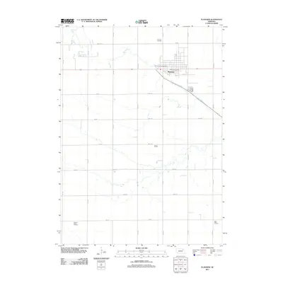
2011 Map of Plainview
USGS Topo · Published 2011About this map
The agricultural hub of Plainview anchors this Northeast Nebraska landscape, where the town's street grid meets the meandering path of Dry Creek. The community layout is clearly defined by local landmarks such as the Plainview Post Office and Chilvers Park Campground, reflecting the organized growth of a rural center. Surrounding the town, the terrain is partitioned by a precise network of section roads like 865 RD and 862nd RD, which support the local ranching and farming operations indicated by the S and A Feedlot. For those researching family history in Pierce County, the map provides precise locations for three distinct burial grounds: the Plainview Cemetery north of town, Pleasant Ridge Cemetery to the southwest, and Stark Valley Cemetery in the southeast corner. These sites, along with the detailed road network, offer a clear look at the area's rural settlement patterns and local infrastructure.
Find a feature on this map
21 named features on this map. Tap any name to fly to it.
Don’t see what you’re looking for? This feature index may not catch every label — zoom into the map to look around manually.
Map Details
Editions of this 2011 Plainview Map
This is the sole edition of this map. No revisions or reprints were ever made.
Other maps of this area

1955 · Sioux City
USGS Topo · 1:250,000

1958 · Sioux City
USGS Topo · 1:250,000

1959 · Sioux City
USGS Topo · 1:250,000

1963 · Pierce NW
USGS Topo · 1:24,000

1963 · Plainview
USGS Topo · 1:24,000

1963 · Brunswick
USGS Topo · 1:24,000

1963 · Foster
USGS Topo · 1:24,000
1963 · Tilden NE
USGS Topo · 1:24,000
1963 · Tilden NW
USGS Topo · 1:24,000

1974 · Midland
USGS Topo · 1:24,000