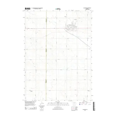
2014 Map of Plainview
USGS Topo · Published 2014About this map
Plainview serves as the primary hub in this agricultural landscape of northeastern Nebraska, situated along the border of Antelope and Pierce Counties. The town is organized on a traditional grid, featuring prominent thoroughfares such as Pilcher Ave, Woodland Ave, and Front St. The surrounding countryside is defined by the ephemeral path of Dry Creek, which meanders across the section lines toward the southeast.
Find a feature on this map
43 named features on this map. Tap any name to fly to it.
Don’t see what you’re looking for? This feature index may not catch every label — zoom into the map to look around manually.
Map Details
Editions of this 2014 Plainview Map
This is the sole edition of this map. No revisions or reprints were ever made.
Other maps of this area

1955 · Sioux City
USGS Topo · 1:250,000

1958 · Sioux City
USGS Topo · 1:250,000

1959 · Sioux City
USGS Topo · 1:250,000

1963 · Pierce NW
USGS Topo · 1:24,000

1963 · Plainview
USGS Topo · 1:24,000

1963 · Brunswick
USGS Topo · 1:24,000

1963 · Foster
USGS Topo · 1:24,000
1963 · Tilden NE
USGS Topo · 1:24,000
1963 · Tilden NW
USGS Topo · 1:24,000

1974 · Midland
USGS Topo · 1:24,000