
1971 Map of Plantation Key
USGS Topo · Published 1973About this map
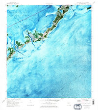
Plantation Key and Upper Matecumbe Key dominate this 1971 orthophotomap, showing the upper Florida Keys as they appeared before the intensive modernization of later decades. The aerial photography reveals the dense vegetation and coral-derived landscape of the era, punctuated by early developments like the Island Community Ch and Coral Shores Sch near the northern end of Plantation Key. In the settlement of Islamorada, the map captures the nautical character of the community, detailing Windley Harbor and the Whale Harbor Channel.
Find a feature on this map
35 named features on this map. Tap any name to fly to it.
Don’t see what you’re looking for? This feature index may not catch every label — zoom into the map to look around manually.
Map Details
Editions of this 1971 Plantation Key Map
2 editions found
Other maps of this area

1947 · Rock Harbor
USGS Topo · 1:24,000

1949 · Rock Harbor
USGS Topo · 1:24,000

1956 · Miami
USGS Topo · 1:250,000

1958 · Miami
USGS Topo · 1:250,000

1971 · Upper Matecumbe Key
USGS Topo · 1:24,000

1971 · Tavernier
USGS Topo · 1:24,000
1971 · Lower Matecumbe Key
USGS Topo · 1:24,000

1972 · Calusa Keys
USGS Topo · 1:24,000
1982 · Homestead
USGS Topo · 1:100,000

1983 · Islamorada
USGS Topo · 1:100,000
Featured Places
- Islamorada, FL
- Plantation Key, FL
- Plantation Key Colony, Islamorada
- Plantation, Islamorada
- Monroe County, FL