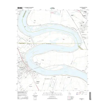
2015 Map of Plaquemine
USGS Topo · Published 2015About this map
The Mississippi River winds through a landscape defined by industrial shipping and deep-rooted agricultural history in this 2015 study. The city of Plaquemine serves as a focal point where the Intracoastal Waterway and Bayou Plaquemine meet the main river channel. This area preserves vestiges of its plantation economy, with the Evergreen Plantation, Saint Louis Plantation, and Allemania tracts still clearly delineated along the western banks. On the opposite shore, newer residential developments such as University Shadows and Sable Chase signify the expanding suburban reach of the nearby state capital. The map captures the complex geography of the river's bends, including Manchac Bend and Missouri Bend, while documenting significant local landmarks like the Southern Helicopters Airport and the Plaquemine Sunshine Ferry Xing. Local heritage is anchored by several sites of interest for genealogists, including the Laboring Society Cem and Rock Zion Cem.
Find a feature on this map
147 named features on this map. Tap any name to fly to it.
Don’t see what you’re looking for? This feature index may not catch every label — zoom into the map to look around manually.
Map Details
Editions of this 2015 Plaquemine Map
This is the sole edition of this map. No revisions or reprints were ever made.
Other maps of this area

1908 · Baton Rouge
USGS Topo · 1:62,500

1935 · Chicot Lake
USGS Topo · 1:62,500

1936 · White Castle
USGS Topo · 1:62,500

1939 · Baton Rouge
USGS Topo · 1:62,500

1940 · Grosse Tete
USGS Topo · 1:62,500

1953 · Baton Rouge West
USGS Topo · 1:24,000

1953 · Crescent
USGS Topo · 1:24,000

1953 · Plaquemine
USGS Topo · 1:24,000

1953 · Lobdell
USGS Topo · 1:24,000

1953 · Addis
USGS Topo · 1:24,000