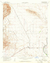
1957 Map of Plaster City
USGS Topo · Published 1961About this map
Industrial gypsum mining and military testing define this arid expanse of the Yuha Desert during the mid-1950s. The settlement of Plaster City serves as a hub for the local economy, dominated by the large Gypsum Plant and supported by the Mining Railroad stretching north toward Fish Creek Mountains. To the east, the landscape transitions into a heavy military footprint within the Naval Reservation, featuring a Parachute Testing Unit, an Observation Tower, and designated Target Areas.
Find a feature on this map
36 named features on this map. Tap any name to fly to it.
Don’t see what you’re looking for? This feature index may not catch every label — zoom into the map to look around manually.
Map Details
Editions of this 1957 Plaster City Map
2 editions found
Other maps of this area

1915 · El Centro
USGS Topo · 1:125,000

1931 · Vallecito
USGS Topo · 1:125,000

1931 · Carrizo
USGS Topo · 1:125,000

1939 · Jacumba
USGS Topo · 1:62,500

1940 · Brawley
USGS Topo · 1:62,500

1940 · Kane Spring
USGS Topo · 1:62,500

1940 · Heber
USGS Topo · 1:62,500

1940 · Plaster City
USGS Topo · 1:62,500

1940 · Coyote Wells
USGS Topo · 1:62,500

1942 · Barrel Spring
USGS Topo · 1:62,500