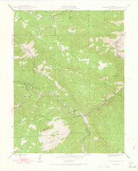
1945 Map of Platte Canyon
USGS Topo · Published 1955About this map
The South Platte River carves a deep path through the canyon lands of the Pike National Forest in this mid-century survey. The convergence of the North Fork South Platte River and the main stem at the settlement of South Platte serves as a focal point for the region's transport and water infrastructure. Smaller mountain communities and stops like Foxton, Longview, and Vermillion follow the winding river valley, while the presence of the Intake and the involvement of the Denver Board of Water Commissioners highlight the area's importance to the metropolitan water supply. High peaks such as Raleigh Peak, Sheep Mountain, and Turkshead Peak define the surrounding terrain. Local education is represented by the isolated Lamb Sch and South Platte Sch, providing a look at the scattered mountain settlements before post-war consolidation altered the rural school landscape.
Find a feature on this map
35 named features on this map. Tap any name to fly to it.
Don’t see what you’re looking for? This feature index may not catch every label — zoom into the map to look around manually.
Map Details
Editions of this 1945 Platte Canyon Map
2 editions found
Other maps of this area

1893 · Platte Canyon
USGS Topo · 1:125,000

1899 · West Denver
USGS Topo · 1:125,000

1942 · Littleton
USGS Topo · 1:31,680

1945 · Indian Hills
USGS Topo · 1:31,680

1945 · Platte Canyon
USGS Topo · 1:24,000

1945 · Pine
USGS Topo · 1:24,000

1945 · Kassler
USGS Topo · 1:24,000

1948 · Kassler
USGS Topo · 1:24,000

1948 · Pine
USGS Topo · 1:24,000

1948 · Platte Canyon
USGS Topo · 1:24,000