
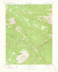
1945 Map of Platte Canyon
USGS Topo · Published 1955About this map
Platte Canyon serves as the central geographic feature of this mid-century survey, where the South Platte River carves through the Front Range terrain of the Pike National Forest. The landscape is defined by its water infrastructure and scattered small communities, including Foxton, Argyle, and Longview. The presence of the Intake near the junction of the South Fork and the North Fork South Platte River highlights the area's importance to the Denver Board of Water Commissioners for regional water management. Educational landmarks such as the Lamb Sch and South Platte Sch provide specific points of interest for genealogists tracing local families. Dominant topographical features like Dome Rock, Sheep Mountain, and Turkshead Peak overlook a network of gulches including Kennedy Gulch and Cottonwood Gulch, illustrating the complex drainage patterns that feed into the canyon floor.
Find a feature on this map
34 named features on this map. Tap any name to fly to it.
Don’t see what you’re looking for? This feature index may not catch every label — zoom into the map to look around manually.
Map Details
Editions of this 1945 Platte Canyon Map
2 editions found
Other maps of this area

1893 · Platte Canyon
USGS Topo · 1:125,000

1899 · West Denver
USGS Topo · 1:125,000

1942 · Littleton
USGS Topo · 1:31,680

1945 · Indian Hills
USGS Topo · 1:31,680

1945 · Pine
USGS Topo · 1:24,000

1945 · Kassler
USGS Topo · 1:24,000

1948 · Kassler
USGS Topo · 1:24,000

1948 · Pine
USGS Topo · 1:24,000

1948 · Platte Canyon
USGS Topo · 1:24,000

1953 · Denver
USGS Topo · 1:250,000