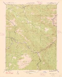
1948 Map of Platte Canyon
USGS Topo · Published 1948About this map
The confluence of the North Fork South Platte River and the main stem of the South Platte River anchors this postwar survey, where the rugged topography of the Pike National Forest meets the engineering interests of the Denver Board of Water Commissioners. Small mountain settlements like Foxton, Critchell, and Buffalo Park are connected by winding mountain roads that follow the drainage of Kennedy Gulch and South Fork Deer Creek. These hamlets represent the early twentieth-century character of the Front Range before modern development intensified.
Find a feature on this map
36 named features on this map. Tap any name to fly to it.
Don’t see what you’re looking for? This feature index may not catch every label — zoom into the map to look around manually.
Map Details
Editions of this 1948 Platte Canyon Map
2 editions found
Other maps of this area

1893 · Platte Canyon
USGS Topo · 1:125,000

1899 · West Denver
USGS Topo · 1:125,000

1942 · Littleton
USGS Topo · 1:31,680

1945 · Indian Hills
USGS Topo · 1:31,680

1945 · Platte Canyon
USGS Topo · 1:24,000

1945 · Pine
USGS Topo · 1:24,000

1945 · Kassler
USGS Topo · 1:24,000

1948 · Kassler
USGS Topo · 1:24,000

1948 · Pine
USGS Topo · 1:24,000

1948 · Platte Canyon
USGS Topo · 1:24,000