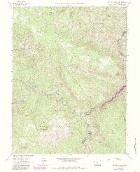
1965 Map of Platte Canyon
USGS Topo · Published 1985About this map
South Platte River and its confluence with the North Fork anchor this mountain landscape within the Pike National Forest. The map documents a scattered network of rural settlements and family estates, including Reynolds Ranch and the community of Foxton. Land use is defined by a mix of recreation and industry, evidenced by the Top of the World Campground and the Little Patsy Quarry. The terrain is punctuated by distinctive geological features like Dome Rock and Chair Rocks, which loom over the deep South Platte River Canyon. Significant infrastructure such as the Strontia Spring and various Quarries reflect the area's development. This survey, updated with 1980s data, tracks the evolving footprints of mountain life in Jefferson County and Douglas County before more modern suburban expansion.
Find a feature on this map
53 named features on this map. Tap any name to fly to it.
Don’t see what you’re looking for? This feature index may not catch every label — zoom into the map to look around manually.
Map Details
Editions of this 1965 Platte Canyon Map
3 editions found
Other maps of this area

1893 · Platte Canyon
USGS Topo · 1:125,000

1899 · West Denver
USGS Topo · 1:125,000

1942 · Littleton
USGS Topo · 1:31,680

1945 · Indian Hills
USGS Topo · 1:31,680

1945 · Platte Canyon
USGS Topo · 1:24,000

1945 · Pine
USGS Topo · 1:24,000

1945 · Kassler
USGS Topo · 1:24,000

1948 · Kassler
USGS Topo · 1:24,000

1948 · Pine
USGS Topo · 1:24,000

1948 · Platte Canyon
USGS Topo · 1:24,000