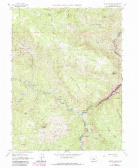
1965 Map of Platte Canyon
USGS Topo · Published 1988About this map
The confluence of the North Fork South Platte River and the main branch defines this canyon landscape on the edge of the Pike National Forest. In the mid-1960s, the terrain shows a mix of scattered ranching, recreation, and early water management, anchored by the Reynolds Ranch and the community at South Platte. The map traces the winding course of the South Platte River as it carves through Platte Canyon, where modern infrastructure begins to appear in the form of a Radio Tower and the Strontia Spring Reservoir, the latter of which was updated in later revisions.
Find a feature on this map
47 named features on this map. Tap any name to fly to it.
Don’t see what you’re looking for? This feature index may not catch every label — zoom into the map to look around manually.
Map Details
Editions of this 1965 Platte Canyon Map
3 editions found
Other maps of this area

1893 · Platte Canyon
USGS Topo · 1:125,000

1899 · West Denver
USGS Topo · 1:125,000

1942 · Littleton
USGS Topo · 1:31,680

1945 · Indian Hills
USGS Topo · 1:31,680

1945 · Platte Canyon
USGS Topo · 1:24,000

1945 · Pine
USGS Topo · 1:24,000

1945 · Kassler
USGS Topo · 1:24,000

1948 · Kassler
USGS Topo · 1:24,000

1948 · Pine
USGS Topo · 1:24,000

1948 · Platte Canyon
USGS Topo · 1:24,000