
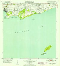
1947 Map of Playa De Ponce NO
USGS Topo · Published 1947About this map
The agricultural and industrial landscape of southern Puerto Rico is clearly defined in this 1940s topography, dominated by the sugar economy. Large landholdings like Hacienda Santa Cruz, Hacienda Estrella, and Hacienda Esperanza occupy the fertile coastal plains, feeding into processing hubs such as Central Constancia and Central Estrella. This era shows the critical connection between inland production and maritime trade, with three major river systems—the Río Portugués, Río Bucaná, and Río Inabón—flowing toward the Mar Caribe. Near the coast, the settlement of Playa de Ponce serves as the gateway for goods passing through the Muelle de Ponce. The map also details the coastal geography of the Caleta de Cabullón, featuring landmarks like Cayo Gato and Pta Cabullón.
Find a feature on this map
17 named features on this map. Tap any name to fly to it.
Don’t see what you’re looking for? This feature index may not catch every label — zoom into the map to look around manually.
Map Details
Editions of this 1947 Playa De Ponce NO Map
This is the sole edition of this map. No revisions or reprints were ever made.
Historical Maps of Vayas Through Time
19 maps found

1945 Playa De Ponce
Ponce Municipio, PR

1946 Punta Cuchara
Ponce Municipio, PR

1947 Adjuntas SE
Ponce Municipio, PR

1947 Jayuya SO
Ponce Municipio, PR

1947 Penuelas NE
Ponce Municipio, PR

1947 Penuelas SE
Ponce Municipio, PR
1947 Playa De Ponce NO
Ponce Municipio, PR

1947 Ponce NO
Ponce Municipio, PR

1947 Ponce SO
Ponce Municipio, PR

1947 Punta Gughara NE
Ponce Municipio, PR
1952 Playa De Ponce
Ponce Municipio, PR

1952 Punta Cuchara
Ponce Municipio, PR

1958 Playa De Ponce
Ponce Municipio, PR

1958 Punta Cucharas
Ponce Municipio, PR

1962 Playa De Ponce
Ponce Municipio, PR
1962 Punta Cucharas
Ponce Municipio, PR
1970 Playa De Ponce
Ponce Municipio, PR

2024 Playa De Ponce
Ponce Municipio, PR

2024 Punta Cucharas
Ponce Municipio, PR