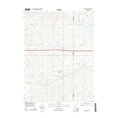
2014 Map of Pleasant Dale
USGS Topo · Published 2014About this map
Pleasant Dale serves as the central hub of this Nebraska landscape, situated near the western edge of the county boundary between Seward Co and Lancaster Co. The area is defined by a dense network of sectional roads and a diverse drainage system feeding into larger reservoirs. To the northeast, the western reaches of Pawnee Lake begin to emerge, while the Twin Lakes sit centrally near Holdredge Rd. The village itself is positioned south of O St Rd, with local history preserved at the Pleasant Dale Cem. Numerous waterways carve through the terrain, including S Br Middle Cr, Culver Cr, and Holmes Cr, reflecting the agricultural and hydrological character of the region as it transitioned into the early 21st century.
Find a feature on this map
30 named features on this map. Tap any name to fly to it.
Don’t see what you’re looking for? This feature index may not catch every label — zoom into the map to look around manually.
Map Details
Editions of this 2014 Pleasant Dale Map
This is the sole edition of this map. No revisions or reprints were ever made.
Other maps of this area

1897 · Lincoln
USGS Topo · 1:125,000

1934 · Seward
USGS Topo · 1:48,000

1935 · Dorchester
USGS Topo · 1:48,000

1939 · Seward
USGS Topo · 1:62,500

1940 · Dorchester
USGS Topo · 1:62,500

1955 · Lincoln
USGS Topo · 1:250,000

1957 · Lincoln
USGS Topo · 1:250,000

1958 · Lincoln
USGS Topo · 1:250,000
1964 · Crete North
USGS Topo · 1:24,000
1964 · Dorchester
USGS Topo · 1:24,000