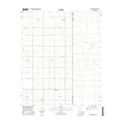
2017 Map of Pleasant Hill
USGS Topo · Published 2017About this map
Pleasant Hill stands as the primary community in this High Plains landscape, situated along the border of New Mexico and Texas. The area is defined by its rectilinear grid of agricultural roads, including Stateline Rd, which marks the boundary between Curry County and Parmer County. Local history is anchored at the Pleasant Hill Cem, located just north of the town center. The terrain is relatively level but punctuated by intermittent drainage patterns, most notably Running Water Draw in the south and Catfish Draw to the northeast. Near the state line, McKillip Lake provides a rare point of surface water in an otherwise dry farming and ranching region. The map captures the highly organized township and range system, where county roads such as Curry Road 24 and C R 18 facilitate movement across the vast agricultural sections.
Find a feature on this map
43 named features on this map. Tap any name to fly to it.
Don’t see what you’re looking for? This feature index may not catch every label — zoom into the map to look around manually.
Map Details
Editions of this 2017 Pleasant Hill Map
This is the sole edition of this map. No revisions or reprints were ever made.
Other maps of this area

1954 · Clovis
USGS Topo · 1:250,000

1957 · Clovis
USGS Topo · 1:62,500

1957 · Pleasant Hill
USGS Topo · 1:62,500

1958 · Clovis
USGS Topo · 1:250,000

1963 · Oklahoma Lane
USGS Topo · 1:24,000

1965 · Bovina
USGS Topo · 1:24,000

1965 · Rhea
USGS Topo · 1:24,000

1985 · Pleasant Hill NW
USGS Topo · 1:24,000

1985 · Muleshoe
USGS Topo · 1:100,000

1985 · Pleasant Hill
USGS Topo · 1:24,000