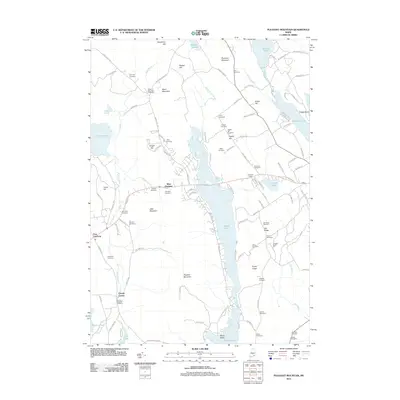
2011 Map of Pleasant Mountain
USGS Topo · Published 2011About this map
Moose Pond dominates the central corridor of this western Maine landscape, stretching south past the prominent peaks of Pleasant Mountain and Plummer Mountain. The area is characterized by a dense network of family and community burial grounds, including the Black Mountain Cemetery, Libby Cemetery, and Sawyer Cemetery, reflecting the long-established settlement patterns of Cumberland County. Small communities like West Bridgton and Liberty Corner are situated along the primary roads, while numerous brooks such as Dock Brook and Sawyer Brook drain the wooded uplands. The terrain rises sharply from the lake shores to various peaks like Ingalls Hill and Knolls Point, where residential developments such as Hio Ridge Shrs indicate the more recent transition of this area into a recreational and residential destination.
Find a feature on this map
121 named features on this map. Tap any name to fly to it.
Don’t see what you’re looking for? This feature index may not catch every label — zoom into the map to look around manually.
Map Details
Editions of this 2011 Pleasant Mountain Map
This is the sole edition of this map. No revisions or reprints were ever made.
Other maps of this area

1896 · Norway
USGS Topo · 1:62,500

1896 · Sebago
USGS Topo · 1:62,500

1909 · Fryeburg
USGS Topo · 1:62,500

1910 · Kezar Falls
USGS Topo · 1:48,000

1911 · Fryeburg
USGS Topo · 1:62,500

1911 · Kezar Falls
USGS Topo · 1:62,500

1941 · Fryeburg
USGS Topo · 1:62,500

1942 · Sebago Lake
USGS Topo · 1:62,500

1943 · Sebago Lake
USGS Topo · 1:62,500

1946 · Norway
USGS Topo · 1:62,500