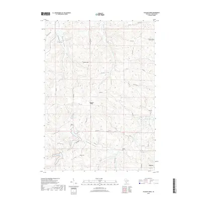
2018 Map of Pleasant Ridge
USGS Topo · Published 2018About this map
Wyoming Valley and Pleasant Valley anchor this Iowa County landscape, where the terrain is defined by a dense network of coulees and hollows typical of the Driftless Area. The settlement of Pleasant Ridge sits atop the high ground between Rush Cr and Meudt Cr, while the village of Ridgeway occupies the southeastern corner. This area is notably dense with local history markers, including the Wyoming Cem, Pleasant Valley Cem, and Rockwell Mills Cem, suggesting long-established farming communities tied to the surrounding drainages. Recreational and natural features such as Cox Hollow Lake and Halverson Lake dominate the southwestern quadrant, connected by the Meadow Valley Trail. The road network, including Hillside School Rd and Amacher Hollow Rd, follows the irregular topography of ridges and valleys like Jones Valley and Yagers Hollow.
Find a feature on this map
52 named features on this map. Tap any name to fly to it.
Don’t see what you’re looking for? This feature index may not catch every label — zoom into the map to look around manually.
Map Details
Editions of this 2018 Pleasant Ridge Map
This is the sole edition of this map. No revisions or reprints were ever made.
Other maps of this area

1902 · Mineral Point
USGS Topo · 1:125,000

1905 · Richland Center
USGS Topo · 1:125,000

1920 · Blue Mounds
USGS Topo · 1:62,500

1922 · Blue Mounds
USGS Topo · 1:62,500

1923 · Blanchardville
USGS Topo · 1:62,500

1952 · Dodgeville
USGS Topo · 1:24,000

1954 · Rockford
USGS Topo · 1:250,000

1955 · Rockford
USGS Topo · 1:250,000

1957 · Madison
USGS Topo · 1:250,000

1958 · Rockford
USGS Topo · 1:250,000