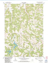
1983 Map of Pleasant Ridge
USGS Topo · Published 1983About this map
Governor Dodge State Park dominates the southern landscape of this 1983 survey, centered on the bifurcated waters of Twin Valley Lake and Cox Hollow Lake. The terrain is defined by the prominent Pleasant Ridge running north to south, separating the drainage of Jones Valley Creek and Lowery Creek from the western valleys. The map documents a rural Iowa County landscape where agricultural life centers on small crossroads and family-named landmarks.
Find a feature on this map
54 named features on this map. Tap any name to fly to it.
Don’t see what you’re looking for? This feature index may not catch every label — zoom into the map to look around manually.
Map Details
Editions of this 1983 Pleasant Ridge Map
This is the sole edition of this map. No revisions or reprints were ever made.
Other maps of this area

1902 · Mineral Point
USGS Topo · 1:125,000

1905 · Richland Center
USGS Topo · 1:125,000

1920 · Blue Mounds
USGS Topo · 1:62,500

1922 · Blue Mounds
USGS Topo · 1:62,500

1923 · Blanchardville
USGS Topo · 1:62,500

1952 · Dodgeville
USGS Topo · 1:24,000

1954 · Rockford
USGS Topo · 1:250,000

1955 · Rockford
USGS Topo · 1:250,000

1957 · Madison
USGS Topo · 1:250,000

1958 · Rockford
USGS Topo · 1:250,000