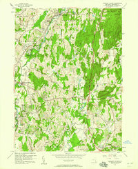
1957 Map of Pleasant Valley
USGS Topo · Published 1958About this map
Wappinger Creek winds through a landscape of mid-century suburban expansion and established rural hamlets in central Dutchess County. The mid-1950s terrain reveals a mix of residential developments like Colonial Heights and Timothy Heights alongside traditional centers such as Pleasant Valley and Lagrangeville. A distinct era of infrastructure is visible in the route of the New York New Haven and Hartford railroad and the State Parkway, while the Old Railroad Grade indicates shifts in the local transit network. Local history is anchored by sites like the Beth-El Cem, Overlook Sch, and James Baird State Park. An unusual level of detail is provided by the inclusion of unchecked fence and field lines, offering a rare look at the fine-grained property boundaries and agricultural partitions that defined the area during this period.
Find a feature on this map
65 named features on this map. Tap any name to fly to it.
Don’t see what you’re looking for? This feature index may not catch every label — zoom into the map to look around manually.
Map Details
Editions of this 1957 Pleasant Valley Map
3 editions found
Other maps of this area

1893 · Clove
USGS Topo · 1:62,500

1893 · Poughkeepsie
USGS Topo · 1:62,500

1894 · Clove
USGS Topo · 1:62,500

1894 · Poughkeepsie
USGS Topo · 1:62,500

1898 · Clove
USGS Topo · 1:62,500

1898 · Rhinebeck
USGS Topo · 1:62,500

1899 · Millbrook
USGS Topo · 1:62,500

1901 · Clove
USGS Topo · 1:62,500

1902 · Millbrook
USGS Topo · 1:62,500

1903 · Poughkeepsie
USGS Topo · 1:62,500