
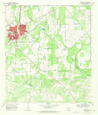
1968 Map of Pleasanton
USGS Topo · Published 1986About this map
Pleasanton anchors this landscape in Atascosa County, where the Atascosa River flows past the town center as the central drainage for several regional creeks including Galvan Creek and Bonita Creek. The settlement pattern follows the Missouri Pacific railroad line, which runs north-south through the quadrangle, passing through the smaller community of Coughran. The southern portion of the map is dominated by energy and resource extraction, notably the Imogene Oil Field and scattered Gravel Pits along East Metate Creek. For genealogists and local historians, this survey preserves the location of essential community hubs such as Saint Andrews Ch and its associated Saint Andrews Cem, alongside the San Ysidro Ch and the smaller Sotelo Cem. The topography reveals a mix of agricultural terrain and industrial utility, including various pumping stations and the distinct Rips Lake.
Find a feature on this map
36 named features on this map. Tap any name to fly to it.
Don’t see what you’re looking for? This feature index may not catch every label — zoom into the map to look around manually.
Map Details
Editions of this 1968 Pleasanton Map
2 editions found
Other maps of this area

1953 · Crystal City
USGS Topo · 1:250,000

1954 · San Antonio
USGS Topo · 1:250,000

1955 · Crystal City
USGS Topo · 1:250,000

1956 · Pleasanton
USGS Topo · 1:62,500

1956 · Jourdanton
USGS Topo · 1:62,500

1957 · San Antonio
USGS Topo · 1:250,000

1961 · Crystal City
USGS Topo · 1:250,000
1964 · Saspamco SE
USGS Topo · 1:24,000

1964 · Leming
USGS Topo · 1:24,000

1968 · Crystal City
USGS Topo · 1:250,000