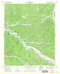
1951 Map of Pleasantville
USGS Topo · Published 1970About this map
The confluence of Cane Creek and Sinking Creek forms the agricultural heart of this landscape along the border of Hickman and Perry counties. Centered on the settlement of Pleasantville, the map reveals a rural society organized around narrow creek valleys and named hollows, where family-named landmarks like Stanley Cem and Duncan Cem document generations of local residency. The valley floor is marked by the presence of the Pleasantville School and several community hubs, including the Farmers Exchange and a local community center. The terrain is deeply dissected, with ridges separated by dozens of named drainages such as Shelving Rock Hollow and Sugarcamp Hollow. This 1951 survey, with 1968 photorevisions, shows the development of the Jim McCord Highway and a prominent pipeline cutting across the topography, illustrating the mid-century modernization of this otherwise traditional Tennessee river-valley environment.
Find a feature on this map
62 named features on this map. Tap any name to fly to it.
Don’t see what you’re looking for? This feature index may not catch every label — zoom into the map to look around manually.
Map Details
Editions of this 1951 Pleasantville Map
2 editions found
Other maps of this area

1936 · Graves Spring
USGS Topo · 1:24,000

1936 · Pleasantville
USGS Topo · 1:24,000

1936 · Coble
USGS Topo · 1:24,000

1936 · Beaverdam Springs
USGS Topo · 1:24,000

1936 · Whitfield
USGS Topo · 1:24,000

1936 · Linden
USGS Topo · 1:24,000

1936 · Chestnut Grove
USGS Topo · 1:24,000

1936 · Lobelville
USGS Topo · 1:24,000

1936 · Kimmins
USGS Topo · 1:24,000
1950 · Linden
USGS Topo · 1:24,000