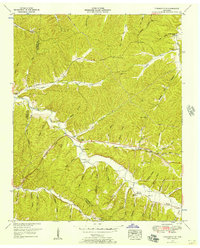
1951 Map of Pleasantville
USGS Topo · Published 1957About this map
The Perry Co Hickman Co border runs through this mid-century landscape of deep hollows and creek valleys, where small farming communities are connected by the winding Jim Mc Gord Highway. Along the banks of Upper Sinking Creek, the settlement of Pleasantville serves as a local anchor with the Pleasantville School and nearby Beech Grove Cem. The map reveals a highly localized social geography defined by numerous hollows, such as Thompson Hollow and Negro Hollow, which sheltered family homes and small churches. To the southeast, Farmers Exchange and Bethel Ch stand at the intersection of several valleys, reflecting the decentralized settlement pattern typical of the Highland Rim. This 1951 field examination captures the area just as modern infrastructure began to overlay the older network of family cemeteries like Ayers Cem and Elkins Cem and one-room schools like Upper Sinking School.
Find a feature on this map
79 named features on this map. Tap any name to fly to it.
Don’t see what you’re looking for? This feature index may not catch every label — zoom into the map to look around manually.
Map Details
Editions of this 1951 Pleasantville Map
2 editions found
Other maps of this area

1936 · Graves Spring
USGS Topo · 1:24,000

1936 · Pleasantville
USGS Topo · 1:24,000

1936 · Coble
USGS Topo · 1:24,000

1936 · Beaverdam Springs
USGS Topo · 1:24,000

1936 · Whitfield
USGS Topo · 1:24,000

1936 · Linden
USGS Topo · 1:24,000

1936 · Chestnut Grove
USGS Topo · 1:24,000

1936 · Lobelville
USGS Topo · 1:24,000

1936 · Kimmins
USGS Topo · 1:24,000
1950 · Linden
USGS Topo · 1:24,000