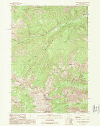
1989 Map of Plenty Coups Peak
USGS Topo · Published 1989About this map
Yellowstone National Park meets the high-altitude reaches of the Shoshone National Forest Absaroka Wilderness in this 1980s topographic study. The landscape is defined by its massive peaks and the corridors of the Shoshone National Forest Washakie Wilderness, showcasing the intersection of multiple protected alpine regions. Centered on the towering Plenty Coups Peak, the map records the complex drainage systems of Middle Creek and Beaverdam Creek. Civil development is concentrated at the East Entrance Ranger Station along the Entrance Road, providing a precise look at the gateway to the park before modern modifications. Other prominent summits, including Reservation Peak, Arthur Peak, and Mount Langford, anchor the terrain, while landmarks such as Crouch and Atkins Peak mark the southern stretches of the forest boundary.
Find a feature on this map
18 named features on this map. Tap any name to fly to it.
Don’t see what you’re looking for? This feature index may not catch every label — zoom into the map to look around manually.
Map Details
Editions of this 1989 Plenty Coups Peak Map
This is the sole edition of this map. No revisions or reprints were ever made.
Other maps of this area

1885 · Lake
USGS Topo · 1:125,000

1886 · Canyon
USGS Topo · 1:125,000

1893 · Ishawooa
USGS Topo · 1:125,000

1895 · Ishawooa
USGS Topo · 1:125,000

1895 · Canyon
USGS Topo · 1:125,000

1895 · Lake
USGS Topo · 1:125,000

1896 · Lake
USGS Topo · 1:125,000

1896 · Canyon
USGS Topo · 1:125,000

1896 · Crandall Creek
USGS Topo · 1:125,000

1899 · Crandall
USGS Topo · 1:125,000