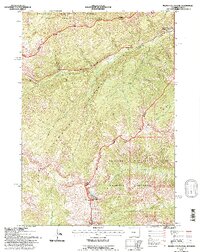
1991 Map of Plenty Coups Peak
USGS Topo · Published 1997About this map
Plenty Coups Peak and the high ridges of the Absaroka Range dominate this 1991 survey of the eastern approach to one of America's most famous natural landscapes. This area serves as a critical junction of federal lands, where the Yellowstone National Park boundary meets the Shoshone National Forest, North Absaroka Wilderness, and Washakie Wilderness. The East Entrance Road snakes through the canyon of Middle Creek toward the East Entrance Ranger Station, a vital gateway for travelers. This map captures the intricate drainage systems and high-altitude topography, including Mount Langford and Reservation Peak, before the implementation of more modern digital mapping. It offers a clear view of the complex management boundaries and the network of creeks like Cabin Creek and Crouch Creek that define the watershed of the Park County high country.
Find a feature on this map
20 named features on this map. Tap any name to fly to it.
Don’t see what you’re looking for? This feature index may not catch every label — zoom into the map to look around manually.
Map Details
Editions of this 1991 Plenty Coups Peak Map
This is the sole edition of this map. No revisions or reprints were ever made.
Other maps of this area

1885 · Lake
USGS Topo · 1:125,000

1886 · Canyon
USGS Topo · 1:125,000

1893 · Ishawooa
USGS Topo · 1:125,000

1895 · Ishawooa
USGS Topo · 1:125,000

1895 · Canyon
USGS Topo · 1:125,000

1895 · Lake
USGS Topo · 1:125,000

1896 · Lake
USGS Topo · 1:125,000

1896 · Canyon
USGS Topo · 1:125,000

1896 · Crandall Creek
USGS Topo · 1:125,000

1899 · Crandall
USGS Topo · 1:125,000