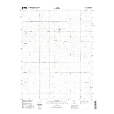
2015 Map of Plevna
USGS Topo · Published 2015About this map
The Plevna settlement stands as the central hub of this agricultural landscape in Reno County, situated just north of the meandering N Fork Ninnescah River. This 2015 survey reveals a classic Great Plains grid of rural roads and section boundaries, where family history is etched into the land at sites like the Hazen Cem and Plevna Cem. The southern reaches of the quadrangle include the Old Langdon Cem and the Balnum Cem, providing essential markers for genealogists tracing early residents of this prairie region. Long, straight thoroughfares such as Sterling Rd and W Morgan Ave define the movement of modern commerce and local history, connecting dispersed farmsteads across the township lines of T24S R9W and T25S R9W.
Find a feature on this map
34 named features on this map. Tap any name to fly to it.
Don’t see what you’re looking for? This feature index may not catch every label — zoom into the map to look around manually.
Map Details
Editions of this 2015 Plevna Map
This is the sole edition of this map. No revisions or reprints were ever made.
Other maps of this area

1892 · Kingman
USGS Topo · 1:125,000

1894 · Kingman
USGS Topo · 1:125,000

1894 · Lyons
USGS Topo · 1:125,000

1955 · Great Bend
USGS Topo · 1:250,000

1955 · Pratt
USGS Topo · 1:250,000

1957 · Great Bend
USGS Topo · 1:250,000

1958 · Great Bend
USGS Topo · 1:250,000

1959 · Pratt
USGS Topo · 1:250,000

1966 · Sterling SW
USGS Topo · 1:24,000
1971 · Little Salt Marsh
USGS Topo · 1:24,000