
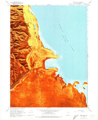
1968 Map of Plug Peak SE
USGS Topo · Published 1972About this map
The waters of the Great Salt Lake dominate this 1968 orthophotomap, showing the lake as it stood following a recorded elevation of 4,193 feet in November 1966. This specific quadrangle captures a vast expanse of open water and the transitional shoreline, including a prominent Mud Flat in the southwest corner. The map provides a unique view of the jurisdictional boundaries that meet within the lake's basin, tracing the intersection of Tooele, Davis, and Salt Lake counties. Because the shoreline is subject to constant change, the document reflects the contemporary state of the lake bed and water levels prior to the significant fluctuations of the late 20th century. Data for this sheet was compiled with assistance from the U.S. Naval Reserve and the Utah Geological and Mineralogical Survey, reflecting a period of collaborative study on the lake's topography and soundings.
Find a feature on this map
7 named features on this map. Tap any name to fly to it.
Don’t see what you’re looking for? This feature index may not catch every label — zoom into the map to look around manually.
Map Details
Editions of this 1968 Plug Peak SE Map
This is the sole edition of this map. No revisions or reprints were ever made.
Other maps of this area

1885 · Tooele Valley
USGS Topo · 1:250,000

1952 · Antelope Island South
USGS Topo · 1:24,000

1952 · Garfield
USGS Topo · 1:24,000

1953 · Tooele
USGS Topo · 1:250,000

1954 · Antelope Island
USGS Topo · 1:24,000

1955 · Mills Junction
USGS Topo · 1:24,000

1955 · Burmester
USGS Topo · 1:24,000

1955 · Tooele
USGS Topo · 1:250,000

1968 · Plug Peak NW
USGS Topo · 1:24,000
1968 · Plug Peak
USGS Topo · 1:24,000