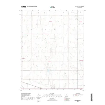
2018 Map of Plum Creek South
USGS Topo · Published 2018About this map
Hamilton-County State Lake sits as a central water feature in this Hamilton County landscape, where the High Plains terrain is defined by a grid of rural routes and seasonal drainages. The Arkansas River cuts across the southern portion of the map, accompanied by the Alamo Ditch, reflecting the critical importance of water management and irrigation in this western Kansas environment. The drainage network is further defined by Plum Cr, Sand Cr, and Dry Cr, which carve subtle paths through the sections. This 2018 survey reveals the persistent structure of the Public Land Survey System, with township and range lines such as t23s r41w organizing the vast agricultural and rangeland tracts. The road network, including RD 15 and RD N, provides a clear view of the modern rural infrastructure used to navigate these open spaces.
Find a feature on this map
27 named features on this map. Tap any name to fly to it.
Don’t see what you’re looking for? This feature index may not catch every label — zoom into the map to look around manually.
Map Details
Editions of this 2018 Plum Creek South Map
This is the sole edition of this map. No revisions or reprints were ever made.
Other maps of this area

1900 · Syracuse
USGS Topo · 1:125,000

1920 · Syracuse
USGS Topo · 1:125,000

1955 · Dodge City
USGS Topo · 1:250,000

1955 · Scott City
USGS Topo · 1:250,000

1958 · Dodge City
USGS Topo · 1:250,000

1958 · Scott City
USGS Topo · 1:250,000

1959 · Dodge City
USGS Topo · 1:250,000
1966 · Tribune 3 SW
USGS Topo · 1:24,000

1966 · Syracuse East
USGS Topo · 1:24,000
1966 · Syracuse West
USGS Topo · 1:24,000