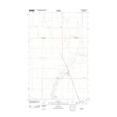
2013 Map of Plummer
USGS Topo · Published 2013About this map
Plummer serves as the central hub of this agricultural landscape in Red Lake County, situated where Co Hwy-1 meets Us-59. The town's civic heart is marked by the local Po and is surrounded by a network of drainage infrastructure essential to the region's farming, including the extensive County Ditch Number Sixtytwo and County Ditch Number Thirtyseven. The Clearwater River meanders across the southern portion of the sheet, its path providing the name for the Clearwater Cem located near its banks. Genealogists will find several notable burial sites recorded here, from the northern Clara Cem to the Saint Vincent De Paul Cem just south of the main settlement. The map clearly delineates the straight-line boundary between Pennington Co and Red Lake Co, illustrating the rigid township and range system that defines the road grid, including 30th Ave SE and 65th St SE.
Find a feature on this map
15 named features on this map. Tap any name to fly to it.
Don’t see what you’re looking for? This feature index may not catch every label — zoom into the map to look around manually.
Map Details
Editions of this 2013 Plummer Map
This is the sole edition of this map. No revisions or reprints were ever made.
Other maps of this area

1918 · Terrebonne
USGS Topo · 1:62,500

1919 · Grit
USGS Topo · 1:62,500

1943 · Thief River Falls
USGS Topo · 1:62,500

1952 · Grand Forks
USGS Topo · 1:250,000

1952 · Thief River Falls
USGS Topo · 1:250,000

1954 · Bemidji
USGS Topo · 1:250,000

1954 · Roseau
USGS Topo · 1:250,000

1956 · Thief River Falls
USGS Topo · 1:250,000

1956 · Grand Forks
USGS Topo · 1:250,000

1957 · Roseau
USGS Topo · 1:250,000