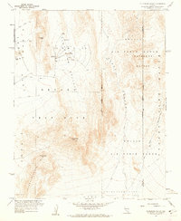
1960 Map of Plutonium Valley
USGS Topo · Published 1962About this map
Nevada Test Site operations dominate this arid landscape, showing the highly specialized infrastructure of the Cold War atomic age. The map center is defined by Plutonium Valley, which contains four distinct points labeled Blast Center and an adjacent Bunker. This area, designated as Area 11, also includes a Radioactive Waste Dump, marking it as a critical zone for nuclear testing and research during the early 1960s.
Find a feature on this map
24 named features on this map. Tap any name to fly to it.
Don’t see what you’re looking for? This feature index may not catch every label — zoom into the map to look around manually.
Map Details
Editions of this 1960 Plutonium Valley Map
3 editions found
Other maps of this area

1907 · Las Vegas
USGS Topo · 1:250,000

1908 · Kawich
USGS Topo · 1:250,000

1908 · Furnace Creek
USGS Topo · 1:250,000

1908 · Las Vegas
USGS Topo · 1:250,000

1910 · Furnace Creek
USGS Topo · 1:250,000

1942 · Emigrant Valley
USGS Topo · 1:125,000

1942 · Indian Spring
USGS Topo · 1:125,000

1942 · Wheelbarrow Peak
USGS Topo · 1:125,000

1942 · Skull Mountain
USGS Topo · 1:125,000

1948 · Death Valley
USGS Topo · 1:250,000