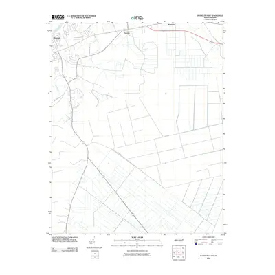
2010 Map of Plymouth East
USGS Topo · Published 2010About this map
Plymouth sits at the western edge of this coastal plain landscape, where the wide Roanoke River transitions into a complex network of wetlands and managed drainage. The terrain is defined by the sharp contrast between the winding, natural course of Conaby Creek and the long, straight agricultural ditches that dominate the eastern reaches near Macedonia. This grid-like water management system reflects the intensive land use of the region, where large parcels are partitioned by thoroughfares like Parker Rd and Slough Rd.
Find a feature on this map
16 named features on this map. Tap any name to fly to it.
Don’t see what you’re looking for? This feature index may not catch every label — zoom into the map to look around manually.
Map Details
Editions of this 2010 Plymouth East Map
This is the sole edition of this map. No revisions or reprints were ever made.
Other maps of this area

1914 · Belhaven
USGS Topo · 1:48,000

1916 · Belhaven
USGS Topo · 1:62,500

1943 · Plymouth
USGS Topo · 1:125,000

1953 · Rocky Mount
USGS Topo · 1:250,000

1954 · Rocky Mount
USGS Topo · 1:250,000

1954 · Plymouth East
USGS Topo · 1:24,000

1954 · Roper North
USGS Topo · 1:24,000

1954 · Roper South
USGS Topo · 1:24,000

1954 · Westover
USGS Topo · 1:24,000
1954 · Pungo Lake
USGS Topo · 1:24,000