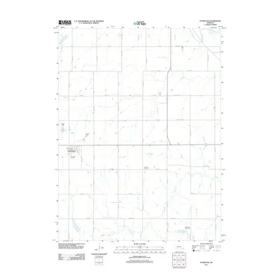
2011 Map of Plymouth
USGS Topo · Published 2011About this map
Plymouth serves as the central hub of this agricultural landscape in Jefferson County, defined by a rigid grid of country roads and the winding paths of local waterways. The settlement is anchored by the Plymouth Post Office and the nearby Woodlawn Cemetery, while the surrounding rural sections are punctuated by critical water management infrastructure. Both the Freese Reservoir, held by the Freese Dam, and the larger Cub Creek Reservoir G-20 with its associated Cub Creek Dam G-20 illustrate the region's reliance on managed water resources for its farming economy. The natural drainage of the area is further defined by Turkey Creek in the northeast and the meandering Cub Creek which crosses the southern half of the quadrangle. Aside from the main townsite, the Kilpatrick Cemetery stands as a distinct genealogical landmark situated along the section lines to the east.
Find a feature on this map
26 named features on this map. Tap any name to fly to it.
Don’t see what you’re looking for? This feature index may not catch every label — zoom into the map to look around manually.
Map Details
Editions of this 2011 Plymouth Map
This is the sole edition of this map. No revisions or reprints were ever made.
Other maps of this area

1955 · Lincoln
USGS Topo · 1:250,000

1957 · Lincoln
USGS Topo · 1:250,000

1957 · Plymouth
USGS Topo · 1:24,000

1957 · Clatonia
USGS Topo · 1:24,000

1957 · Beatrice West
USGS Topo · 1:24,000

1957 · Wilber
USGS Topo · 1:24,000

1958 · Lincoln
USGS Topo · 1:250,000

1961 · Western SE
USGS Topo · 1:24,000
1961 · Swanton
USGS Topo · 1:24,000

1970 · Diller NE
USGS Topo · 1:24,000