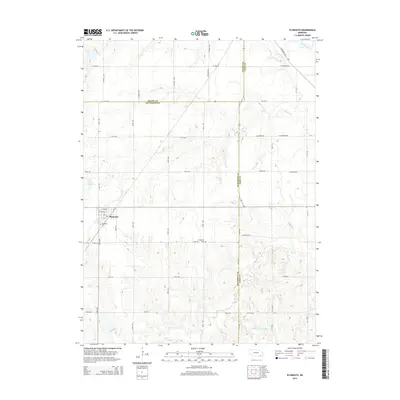
2014 Map of Plymouth
USGS Topo · Published 2014About this map
The village of Plymouth serves as the primary hub in this Jefferson County landscape, characterized by a structured grid of agricultural roads that cross county lines into Saline and Gage. Significant local history is preserved at Woodlawn Cem on the western edge of town and Kilpatrick Cem to the southeast. The drainage systems of Turkey Cr and the Big Blue River in the northeast corner contrast with the managed water resources of the south, specifically Cub Cr Reservoir G-20 and Freese Reservoir. The map illustrates the convergence of three counties—Saline, Jefferson, and Gage—marked by boundaries like Y Rd and W 142 Rd. This layout reveals the late-twentieth-century rural development pattern, where traditional cemeteries and small-town blocks remain anchors within a vast network of section roads.
Find a feature on this map
46 named features on this map. Tap any name to fly to it.
Don’t see what you’re looking for? This feature index may not catch every label — zoom into the map to look around manually.
Map Details
Editions of this 2014 Plymouth Map
This is the sole edition of this map. No revisions or reprints were ever made.
Other maps of this area

1955 · Lincoln
USGS Topo · 1:250,000

1957 · Lincoln
USGS Topo · 1:250,000

1957 · Plymouth
USGS Topo · 1:24,000

1957 · Clatonia
USGS Topo · 1:24,000

1957 · Beatrice West
USGS Topo · 1:24,000

1957 · Wilber
USGS Topo · 1:24,000

1958 · Lincoln
USGS Topo · 1:250,000

1961 · Western SE
USGS Topo · 1:24,000
1961 · Swanton
USGS Topo · 1:24,000

1970 · Diller NE
USGS Topo · 1:24,000