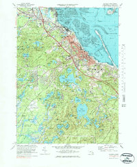
1977 Map of Plymouth
USGS Topo · Published 1984About this map
Plymouth and the surrounding coastal landscape of Plymouth Bay are shown in detail as the region balanced its colonial heritage with modern growth. This 1970s revision highlights the dense network of freshwater ponds and reservoirs south of the town center, including the expansive Billington Sea, Great South Pond, and Little South Pond. The topography reveals the intricate coastal features from Saquish Head to the industrial wharf at Cordage, while the inland areas show the sprawling Myles Standish State Forest and the expanding infrastructure of the Plymouth Municipal Airport. Genealogists and local historians can trace burial sites at St Josephs Cem and Parting Ways Cem, or locate landmarks like the National Monument and Coles Hill near the historic waterfront. The presence of the Conrail line and the dual-campus Plymouth-Carver Sr High School reflect the mid-century development of this South Shore community.
Find a feature on this map
108 named features on this map. Tap any name to fly to it.
Don’t see what you’re looking for? This feature index may not catch every label — zoom into the map to look around manually.
Map Details
Editions of this 1977 Plymouth Map
4 editions found
Other maps of this area

1885 · Abington
USGS Topo · 1:62,500

1885 · Duxbury
USGS Topo · 1:62,500

1885 · Middleboro
USGS Topo · 1:62,500

1886 · Plymouth
USGS Topo · 1:62,500

1888 · Duxbury
USGS Topo · 1:62,500

1888 · Middleboro
USGS Topo · 1:62,500

1888 · Abington
USGS Topo · 1:62,500

1889 · Plymouth
USGS Topo · 1:62,500

1893 · Abington
USGS Topo · 1:62,500

1893 · Duxbury
USGS Topo · 1:62,500