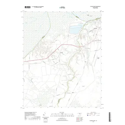
2019 Map of Plymouth West
USGS Topo · Published 2019About this map
The Roanoke River and Middle River dominate this coastal plain landscape where the borders of Bertie, Martin, and Washington counties meet. The town of Plymouth sits at the northeastern corner, serving as a hub for the surrounding rural communities of Dardens, Ren, and Hinson. This 2019 survey documents a complex network of waterways, including Welchs Creek and Charleston Creek, alongside marshy terrain like Cooper Swamp and Lentier Swamp. Significant local landmarks include the Plymouth Municipal Airport and Wards Bridge, while the river itself is dotted with named features such as Purchase Islands and Huff Island. The map records a mix of agriculture and managed timberlands, as seen in the grid-like road patterns around Long Acre and the numerous small prongs and creeks that drain the low-lying interior of the peninsula.
Find a feature on this map
72 named features on this map. Tap any name to fly to it.
Don’t see what you’re looking for? This feature index may not catch every label — zoom into the map to look around manually.
Map Details
Editions of this 2019 Plymouth West Map
This is the sole edition of this map. No revisions or reprints were ever made.
Other maps of this area

1914 · Belhaven
USGS Topo · 1:48,000

1916 · Belhaven
USGS Topo · 1:62,500

1943 · Plymouth
USGS Topo · 1:125,000

1953 · Rocky Mount
USGS Topo · 1:250,000

1954 · Rocky Mount
USGS Topo · 1:250,000

1954 · Plymouth East
USGS Topo · 1:24,000

1954 · Westover
USGS Topo · 1:24,000
1954 · Pike Road
USGS Topo · 1:24,000
1978 · Farmlife
USGS Topo · 1:24,000
1978 · Hoke
USGS Topo · 1:24,000