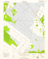
1954 Map of Pike Road
USGS Topo · Published 1957About this map
The low-lying wetlands of eastern North Carolina define this mid-century landscape, where human settlement and drainage engineering intersect across the Washington County and Beaufort County line. Central to the topography is the massive Lees Mills Swamp, a vast expanse of the Dismal region that is meticulously crisscrossed by an extensive network of waterways. Prominent among these is the East Pantego Intercepting Canal and several numbered channels like No 2 and No 3, which serve to manage the water levels of the surrounding marshlands.
Find a feature on this map
29 named features on this map. Tap any name to fly to it.
Don’t see what you’re looking for? This feature index may not catch every label — zoom into the map to look around manually.
Map Details
Editions of this 1954 Pike Road Map
2 editions found
Other maps of this area

1914 · Belhaven
USGS Topo · 1:48,000

1916 · Belhaven
USGS Topo · 1:62,500

1943 · Plymouth
USGS Topo · 1:125,000

1950 · Pinetown
USGS Topo · 1:24,000

1951 · Belhaven
USGS Topo · 1:24,000

1951 · Pantego
USGS Topo · 1:24,000

1953 · Rocky Mount
USGS Topo · 1:250,000

1954 · Rocky Mount
USGS Topo · 1:250,000

1954 · Plymouth East
USGS Topo · 1:24,000

1954 · Roper South
USGS Topo · 1:24,000