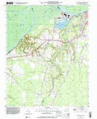
1998 Map of Plymouth West
USGS Topo · Published 2001About this map
The Roanoke River dominates this landscape, winding through a complex network of wetlands and prongs including Broad Creek and Warren Neck Cr. Along the river’s south bank, the town of Plymouth serves as a center of local industry, marked by significant Industrial Waste Ponds and a substation that highlight the area's mid-to-late 20th-century economic footprint. Moving south from the river, the terrain transitions into a patchwork of rural homesteads and agricultural clearings.
Find a feature on this map
40 named features on this map. Tap any name to fly to it.
Don’t see what you’re looking for? This feature index may not catch every label — zoom into the map to look around manually.
Map Details
Editions of this 1998 Plymouth West Map
This is the sole edition of this map. No revisions or reprints were ever made.
Other maps of this area

1914 · Belhaven
USGS Topo · 1:48,000

1916 · Belhaven
USGS Topo · 1:62,500

1943 · Plymouth
USGS Topo · 1:125,000

1953 · Rocky Mount
USGS Topo · 1:250,000

1954 · Rocky Mount
USGS Topo · 1:250,000

1954 · Plymouth East
USGS Topo · 1:24,000

1954 · Westover
USGS Topo · 1:24,000
1954 · Pike Road
USGS Topo · 1:24,000
1978 · Farmlife
USGS Topo · 1:24,000
1978 · Hoke
USGS Topo · 1:24,000