
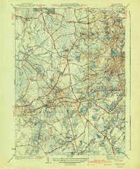
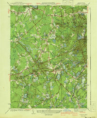
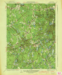
1941 Map of Plympton
USGS Topo · Published 1950About this map
Monponsett Pond and the surrounding cranberry bogs of Plymouth County define this landscape during the mid-century, where agricultural industry and small-town settlements intersect. The map illustrates a region heavily reliant on its wetland geography, with numerous named bogs like Manneros Bog and Shaw Bogs supporting the local economy. Small crossroads communities and hamlets such as Eddyville, Waterville, and Harrubs Corner are connected by a network of roads and the New York New Haven and Hartford railroad line.
Find a feature on this map
58 named features on this map. Tap any name to fly to it.
Don’t see what you’re looking for? This feature index may not catch every label — zoom into the map to look around manually.
Map Details
Editions of this 1941 Plympton Map
4 editions found
Other maps of this area

1885 · Abington
USGS Topo · 1:62,500

1885 · Duxbury
USGS Topo · 1:62,500

1885 · Middleboro
USGS Topo · 1:62,500

1886 · Plymouth
USGS Topo · 1:62,500

1888 · Duxbury
USGS Topo · 1:62,500

1888 · Middleboro
USGS Topo · 1:62,500

1888 · Abington
USGS Topo · 1:62,500

1889 · Plymouth
USGS Topo · 1:62,500

1893 · Abington
USGS Topo · 1:62,500

1893 · Duxbury
USGS Topo · 1:62,500