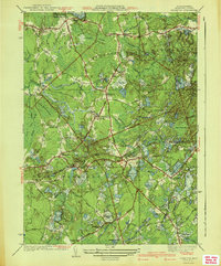
1941 Map of Plympton
USGS Topo · Published 1941About this map
The New York New Haven and Hartford RR carves through the landscape of Plympton and Halifax, serving as a primary transportation artery in this corner of Plymouth County. The terrain is defined by a dense network of wetlands and agriculture, notably the Rocky Meadow Bogs and Shaw Bogs, which speak to the region's long-standing cranberry industry. Local social centers are anchored by small schoolhouses like Soule Sch and the Thomastown Sch, alongside community clusters at Harrys Corner and Shurcliff Corner.
Find a feature on this map
63 named features on this map. Tap any name to fly to it.
Don’t see what you’re looking for? This feature index may not catch every label — zoom into the map to look around manually.
Map Details
Editions of this 1941 Plympton Map
4 editions found
Other maps of this area

1885 · Abington
USGS Topo · 1:62,500

1885 · Duxbury
USGS Topo · 1:62,500

1885 · Middleboro
USGS Topo · 1:62,500

1886 · Plymouth
USGS Topo · 1:62,500

1888 · Duxbury
USGS Topo · 1:62,500

1888 · Middleboro
USGS Topo · 1:62,500

1888 · Abington
USGS Topo · 1:62,500

1889 · Plymouth
USGS Topo · 1:62,500

1893 · Abington
USGS Topo · 1:62,500

1893 · Duxbury
USGS Topo · 1:62,500