2024 Map of Pocatello North
USGS Topo · Published 2024About this map
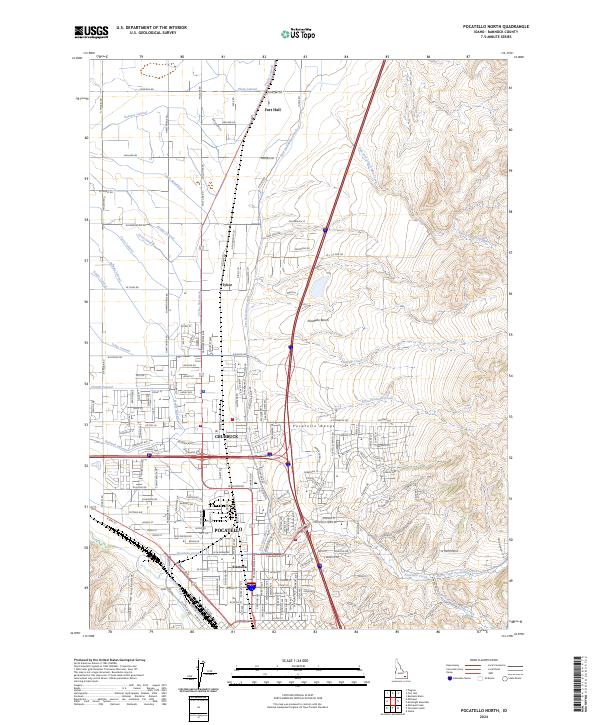
The northern reaches of Pocatello and the city of Chubbuck dominate the southern portion of this landscape, where urban development meets the agricultural irrigation systems of the Snake River Plain. The complex network of water management is visible through numerous named channels such as the Fort Hall Main Canal, Tyhee Wasteway, and Panther Lateral, which support the farms surrounding the community of Tyhee. To the north, the map extends into the southern edge of the Fort Hall area, showing the transition from city blocks to rural section lines.
Find a feature on this map
194 named features on this map. Tap any name to fly to it.
Don’t see what you’re looking for? This feature index may not catch every label — zoom into the map to look around manually.
Map Details
Editions of this 2024 Pocatello North Map
This is the sole edition of this map. No revisions or reprints were ever made.
Other maps of this area

1934 · Michaud
USGS Topo · 1:62,500

1937 · Pocatello
USGS Topo · 1:48,000

1937 · Michaud
USGS Topo · 1:62,500

1940 · Blackfoot
USGS Topo · 1:62,500

1943 · Blackfoot
USGS Topo · 1:62,500

1944 · Pocatello
USGS Topo · 1:62,500

1954 · Pocatello
USGS Topo · 1:250,000
1955 · Pingree
USGS Topo · 1:24,000

1955 · Idaho Falls
USGS Topo · 1:250,000

1958 · Idaho Falls
USGS Topo · 1:250,000