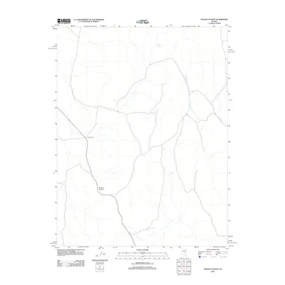
2012 Map of Pogues Station
USGS Topo · Published 2012About this map
Pogues Station serves as the central landmark in this high-desert portion of Nye County, where the topography is defined by the ascent to Red Rock Summit. This landscape is marked by the scarce but vital presence of water sources, such as Duckwater Creek and Soda Spring. The remote character of the region is evident in the sparse network of trails and roads that converge near these water points, including the notably named Nevada Governors Spring in the southern reaches. The arrangement of features suggests a place where survival and travel were historically dictated by the geography of reliable springs and passable mountain gaps.
Find a feature on this map
5 named features on this map. Tap any name to fly to it.
Don’t see what you’re looking for? This feature index may not catch every label — zoom into the map to look around manually.
Map Details
Editions of this 2012 Pogues Station Map
This is the sole edition of this map. No revisions or reprints were ever made.
Other maps of this area

1951 · Green Springs
USGS Topo · 1:62,500

1951 · Pancake Summit
USGS Topo · 1:62,500

1953 · Pinto Summit
USGS Topo · 1:62,500

1956 · Ely
USGS Topo · 1:250,000

1959 · Ely
USGS Topo · 1:250,000

1963 · Ely
USGS Topo · 1:250,000

1964 · Moody Peak
USGS Topo · 1:62,500

1979 · Mt. Hamilton
USGS Topo · 1:100,000

1990 · Pancake Summit SW
USGS Topo · 1:24,000
1990 · Green Springs NW
USGS Topo · 1:24,000