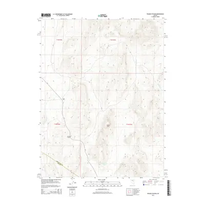
2014 Map of Pogues Station
USGS Topo · Published 2014About this map
Pogues Station serves as the namesake for this high-desert landscape in the modern era, marking a focal point along the winding path of Cr-7 in the western reaches of the quadrangle. The terrain is dominated by the northern extent of the Pancake Range, where high-altitude peaks and basins define the local hydrology. Water sources are scarce but critical, evidenced by the presence of Soda Spring and the Nevada Governors Spring, which support the drainage patterns of Duckwater Cr. The transition between basins is most notable at Red Rock Summit, a prominent landmark for travelers moving through this portion of Nye County. This survey clearly illustrates the administrative divisions of the region, specifically where the border between White Pine and Nye counties intersects the township and range grids of T16N and T15N.
Find a feature on this map
12 named features on this map. Tap any name to fly to it.
Don’t see what you’re looking for? This feature index may not catch every label — zoom into the map to look around manually.
Map Details
Editions of this 2014 Pogues Station Map
This is the sole edition of this map. No revisions or reprints were ever made.
Other maps of this area

1951 · Green Springs
USGS Topo · 1:62,500

1951 · Pancake Summit
USGS Topo · 1:62,500

1953 · Pinto Summit
USGS Topo · 1:62,500

1956 · Ely
USGS Topo · 1:250,000

1959 · Ely
USGS Topo · 1:250,000

1963 · Ely
USGS Topo · 1:250,000

1964 · Moody Peak
USGS Topo · 1:62,500

1979 · Mt. Hamilton
USGS Topo · 1:100,000

1990 · Pancake Summit SW
USGS Topo · 1:24,000
1990 · Green Springs NW
USGS Topo · 1:24,000