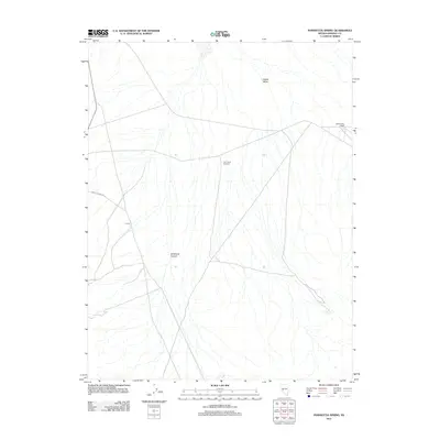
2011 Map of Poinsettia Spring
USGS Topo · Published 2011About this map
Gabbs Valley defines the arid character of this Mineral County landscape, where water sources and ranching infrastructure dictate the patterns of human activity. The map identifies the remote settlement at Lorena and the Gabbs Valley Ranch, providing key coordinates for local historians studying high-desert habitation. Vital water access is marked at Poinsettia Spring, while the presence of the uniquely named Car Frame Windmill reflects the practical adaptations of mid-century livestock management. Transport through this basin relies on a sparse network of desert tracks, most notably Rabbit Springs Rd, which skirts the western edge of the valley near Wildhorse Canyon. The 2011 topography captures the essential features of a sparsely populated Nevada interior, where named landmarks often center on singular points of survival or industry.
Find a feature on this map
7 named features on this map. Tap any name to fly to it.
Don’t see what you’re looking for? This feature index may not catch every label — zoom into the map to look around manually.
Map Details
Editions of this 2011 Poinsettia Spring Map
This is the sole edition of this map. No revisions or reprints were ever made.
Other maps of this area

1909 · Hawthorne
USGS Topo · 1:250,000

1911 · Hawthorne
USGS Topo · 1:250,000

1915 · Hawthorne
USGS Topo · 1:250,000

1948 · Walker Lake
USGS Topo · 1:250,000

1957 · Walker Lake
USGS Topo · 1:250,000

1962 · Walker Lake
USGS Topo · 1:250,000

1964 · Walker Lake
USGS Topo · 1:250,000
1979 · Copper Mtn.
USGS Topo · 1:24,000
1979 · Ramsey Spring
USGS Topo · 1:24,000
1979 · Pilot Cone
USGS Topo · 1:24,000