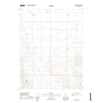
2018 Map of Poinsettia Spring
USGS Topo · Published 2018About this map
Gabbs Valley Range dominates the southern landscape of this Mineral County region, where the high desert terrain transitions into the steep corridors of Wildhorse Canyon. In the 2018 survey, the area remains largely defined by its isolation and the natural water source at Poinsettia Spring, located along the eastern slopes. The desert floor of Gabbs Valley to the north is traversed by a sparse network of historical routes, most notably Rawhide Rd and Rabbit Springs Rd, which connect the remote basin to surrounding mining and ranching districts. This map provides a detailed view of the section lines and township boundaries, including t11n r33e, which govern this vast expanse of public land in the Great Basin.
Find a feature on this map
12 named features on this map. Tap any name to fly to it.
Don’t see what you’re looking for? This feature index may not catch every label — zoom into the map to look around manually.
Map Details
Editions of this 2018 Poinsettia Spring Map
This is the sole edition of this map. No revisions or reprints were ever made.
Other maps of this area

1909 · Hawthorne
USGS Topo · 1:250,000

1911 · Hawthorne
USGS Topo · 1:250,000

1915 · Hawthorne
USGS Topo · 1:250,000

1948 · Walker Lake
USGS Topo · 1:250,000

1957 · Walker Lake
USGS Topo · 1:250,000

1962 · Walker Lake
USGS Topo · 1:250,000

1964 · Walker Lake
USGS Topo · 1:250,000
1979 · Copper Mtn.
USGS Topo · 1:24,000
1979 · Ramsey Spring
USGS Topo · 1:24,000
1979 · Pilot Cone
USGS Topo · 1:24,000